
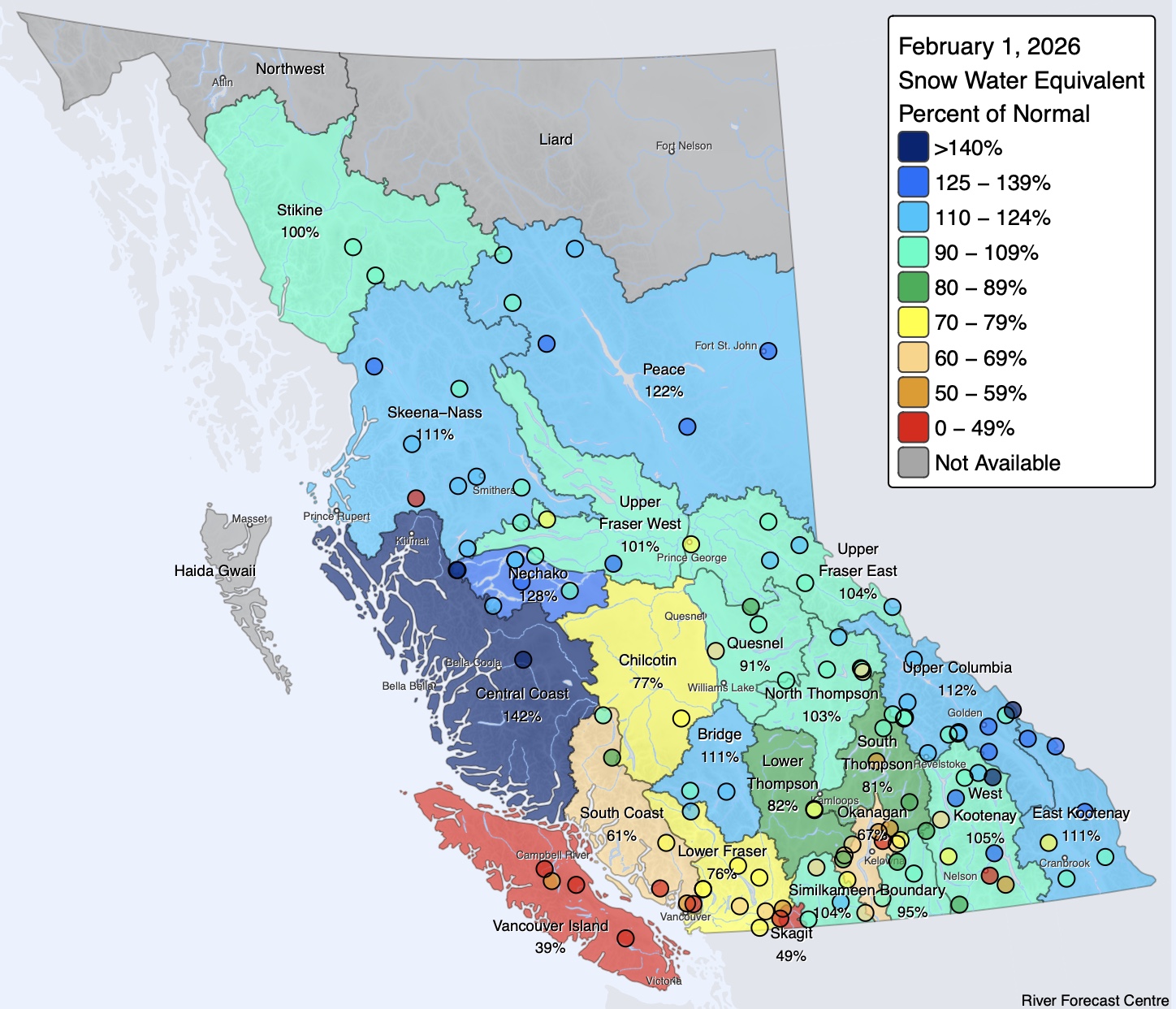
From time to time, we report on the snow water equivalent (SWE) in zones we like to tour. Some data is more readily available than others. In British Columbia, a vast province stretching from the coast to the Rockies, the province releases a snow survey and water supply bulletin each month. These reports discuss data collected from the first of one month to the first of the next—they are made public around mid-month. The latest bulletin was published last week and covers the period between Jan. 1 and Feb. 1.
From a snow quantity standpoint, and let’s go out on a limb and state quality, too, BC has fared well this winter. According to the report, last season at the same date benchmark (Feb. 1), BC’s snow stations were at 72% of average. A year later, on Feb. 1, 2026, the data indicate that the basin is at 96% of average, 4% below normal. This is generally good news, as the report states that by this date, two-thirds of BC’s annual snowfall has already accumulated. This is another way of stating that, over the next two to three months, the region typically accumulates more snow.
For those keeping track of their powder days up north, you likely noticed some recent sustained high pressure with an accompanying lack of snow. On January 1, the province had 107% of its average snowpack—so, in total, there’s been an 11% decrease since then.
Here’s a weather summary from a snow survey report:
“A strong high-pressure ridge persisted over western North America for nearly two weeks in late January, resulting in very dry conditions and little to no snow accumulation, even at higher elevations. Warmer-than-normal temperatures during this period led to snowmelt at some lower-elevation Automated Snow Weather Stations (ASWS). An atmospheric river centered on Vancouver Island during the final days of January, producing minor snowpack increases at higher-elevation stations for the first time in several weeks. Another atmospheric river is forecast to impact the Central and North Coasts this upcoming weekend; however, much of the remainder of the province is expected to return to relatively dry conditions with minimal snow accumulation over the next week.”
Below are province-wide and basin-specific SWE maps to get a better idea of how the snow stacks up.
Leave a Reply
You must be logged in to post a comment.