
The 2026 International Snow Science Workshop was held recently in Whistler. The conference brought together researchers to discuss the latest findings in… snow science. Running through the papers and posters presented, we’ve culled a few we think might interest THR readers. Let’s discuss.
1) “FROM THE CHIC-CHOCS TO THE SEA-TO-SKY CORRIDOR: BACKCOUNTRY USER PREPAREDNESS,” by Élodie Brousseau-Gaumond
If you are looking for good news in the backcountry tourist scene, this paper mostly delivers. The premise is simple: Brousseau-Gaumond compares group/individual preparedness for backcountry travel between a dataset collected in 2017-2018 in the Chic Chocs and data collected in 2024-2025 in the Sea-to-Sky Corridor.
(You can find the full paper here.)
Both locations are in Canada, but differ in proximity to major population centers. The Chic Chocs are roughly 290 miles northwest of Quebec City, while the trailheads where data was collected in the Sea-to-Sky Corridor are roughly a 1- to 1.5-hour drive north of Vancouver and closer to Squamish and Whistler. And according to the author, the 2025-2026 survey questions were similar to the 2017-2018 questions as they relate to gear and avalanche training; they differ, however, in that the more recent survey explored individual and group comprehension of the day’s forecast and avalanche problem(s)—what the author calls “bulletin comprehension.”
Notes: Rescue gear consists of a beacon, shovel, and probe. Further, participants were asked their “highest level of formal avalanche training completed, terrain selected and its ATES rating, and whether the tour was planned using a formal preparation tool. Group leaders were additionally asked, unprompted, to state the day’s official Avalanche Canada danger rating (three-elevation-band format) and to name the avalanche problem(s) identified in that day’s bulletin.”
Here are the results:
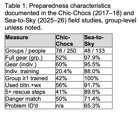
Takeaways from the author relating to group/individual bulletin comprehension.
—28.6% “of group leaders did not correctly state the day’s official danger rating.”
—34.7% “did not correctly identify the forecast avalanche problem. This points to a gap between accessing information and accurately comprehending it in the field, and the stakes make it one worth closing.”
The second paper is titled, “THE INTERSECTION OF SCIENCE AND HUMAN BEHAVIOR IN TERRAIN MANAGEMENT: HOW SOCIAL MEDIA AND ARTIFICIAL INTELLIGENCE ARE CHANGING THE CULTURE,” by Erme Catino. Right up front in the paper’s abstract is a matter-of-fact, and to some, maybe contentious, statement. Catino writes, “A large proportion of backcountry skiers and riders today have moved from basing their tour plan decisions solely from the weather and avalanche forecast, to now incorporating these technological tools into their decision making. While social media (Facebook and Instagram) initially drove this change, applications such as Strava – most notably via their heat map function—and integrating AI into these applications, are changing people’s behavior accessing the backcountry and evaluating terrain. This intersection of science and human behavior is superseding institutional knowledge, giving a false sense of conditions and hazards, and inadvertently opens terrain during periods of higher hazard.”
(You can find the full paper here.)
He adds, “We have long observed the trickle-down effect of a slope opening in the field, attracting more skiers and riders based on tracks. However, backcountry users are now utilizing social media and heat maps to observe where others have traveled and are seemingly basing some decisions on such data points, regardless of the warnings of the local avalanche center and recent observations. The sheep mentality and social acceptance isn’t new, and snow professionals regularly urge caution of this risk during periods of persistent weak layer avalanches.”
Catino’s findings suggest that tourists sometimes made decisions that ran counter to information and warnings in the avalanche bulletin and were more swayed, perhaps, by public routes/segments made available on apps like Strava. (See his methods regarding accessing public routes and heatmaps.)
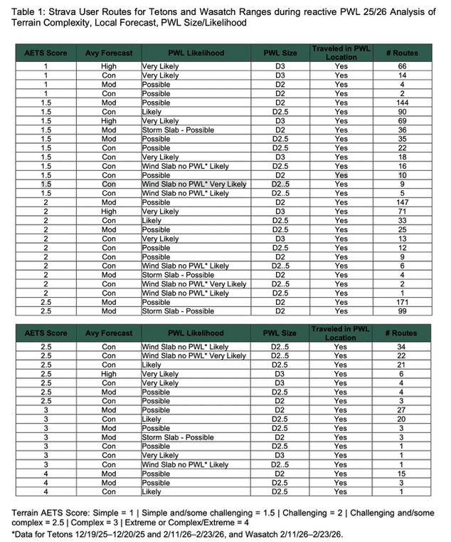
Catino notes about the data:
Results demonstrate that when avalanche forecast rating was Considerable or High with a corresponding avalanche problem likelihood that was “likely” and “very likely,” 87 routes travelled in terrain that was Challenging with some Complex features. Similarly, when the hazard rating was Considerable or High with a corresponding avalanche problem likelihood that was “likely” and “very likely” 24 routes travelled in Complex and Extreme terrain.
By investigating specific dates surrounding sensitive, persistent weak layer avalanche problems, I have collected chronological links demonstrating a relationship between people seemingly trusting the open-source data despite recent avalanches and/or forecasts which contradicted the stability.
Editor’s note: If you are new to the ATES scale, you can find a resource here.
Leave a Reply
You must be logged in to post a comment.