Over the next few months, The High Route will highlight some of the avalanche centers and their good work. We’ll do our best to offer a global perspective. The intent here is not to create a hierarchy of excellence but to connect readers with resources that might ultimately allow them to make better decisions in the backcountry. First up, the Colorado Avalanche Information Center. 


(Full disclosure—The High Route sponsors the Friends of the CAIC and is a media partner. Being a media partner means if/when the CAIC has critical information to disseminate to the backcountry community during their forecasting season, we’ll help them do that.)

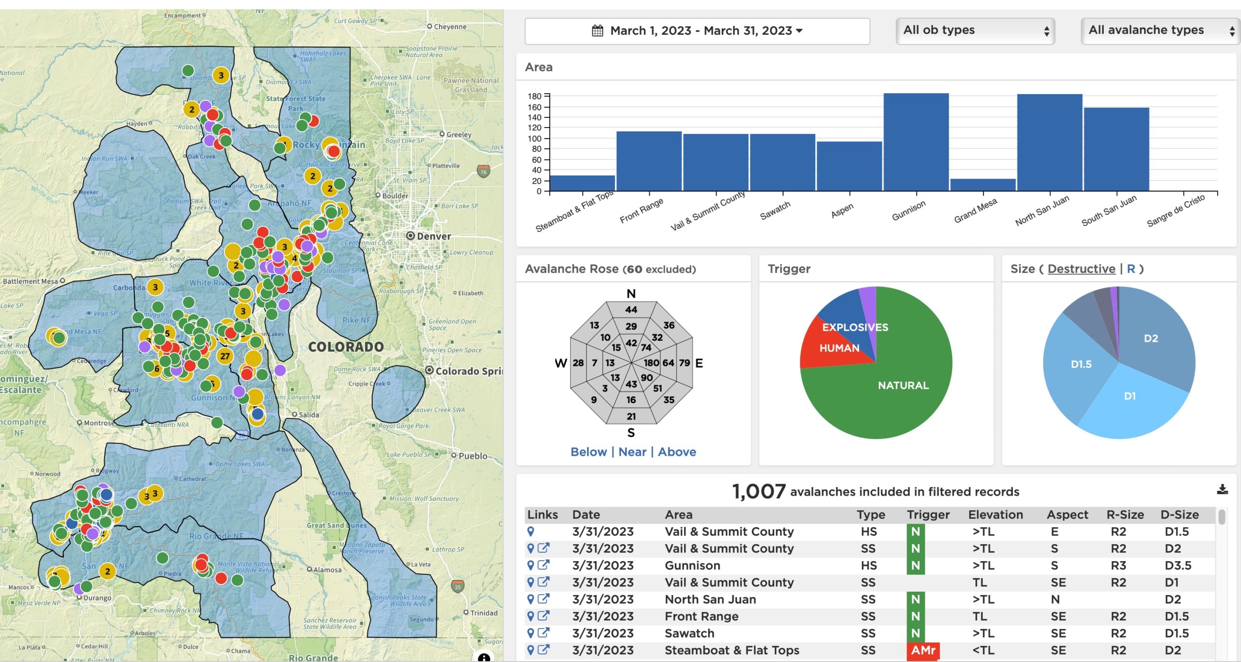
I once skied Colorado’s hills regularly, but now live a several-day drive away and a universe apart, considering my local snowpack and that which is typical in Colorado. In other words, the CAIC forecasters regularly deal with deep, persistent, weak layers. As a lifelong learner, I want to learn what backcountry travelers and forecasters outside my region are finding in their local snowpacks. With the CAIC’s statewide network of professional forecasters, they routinely provide excellent products. I regularly visit the Colorado Avalanche Information Center (CAIC) site. And I find myself routinely learning from them. 

Again, I’m not going to the CAIC for my daily forecast or to monitor how the snowpack may evolve in a particular zone. (I live in Oregon.) However, the following resources can broaden the horizons of any backcountry skier or rider. Last note: we come into this wide-eyed and acknowledge the sometimes macabre aspects of reading avalanche reports. We read accident reports with gratitude and respect, hoping others can take salient lessons into the backcountry.


Avalanche Accident Documentation

The CAIC maintains a comprehensive database of avalanche accidents, including written reports about each major accident within Colorado and the U.S. It also provides a public, downloadable database of reported avalanche accidents between 1952 and 2022.   

  • The Colorado Data is organized by year and several key subgroups (like skier, snowboarder, snowmobiler). On the Colorado Data page, the CAIC also links each accident’s respective report. These accident reports go back to the 1996-1997 season.

  • U.S. DataCAIC also updates and maintains a U.S. avalanche database. Similar to the Colorado data, the CAIC links to all published avalanche accident reports (across the U.S.) for fatal incidents. U.S. data for avalanche fatalities extends back to 2009-2010. 


Avalanche Explorer  

Step 1:

The Avalanche Explorer tool is an excellent resource. It is primarily useful for identifying patterns in CAIC’s database of observations. This tool is exclusive to Colorado but indicates the products well-funded avalanche centers can produce. (You can find a comprehensive guide called Using The Avalanche Explorer Tool here.) Here’s what CAIC says about the Avalanche Explorer: “Avalanche activity often follows patterns where similar avalanches release on similar slopes. You can use the Avalanche Explorer to look for these patterns. Then, use the data to help you avoid slopes that could produce a similar avalanche. You can learn more about avalanche data codes on our Avalanche Coding help page or in Chapter 3 of Snow, Weather, and Avalanches: Observation Guidelines for Avalanche Programs in the United States.”


A screenshot from the CAIC Avalanche Explorer tool with a custom date set from March 1, 2023 - March 31, 2023 with filters set all observation and avalanche types. recorded.

A screenshot from the CAIC Avalanche Explorer tool with a custom date set from March 1, 2023 – March 31, 2023 with filters set all observation and avalanche types. recorded.


Step 2:

The left side of the Avalanche Explorer is an interactive map that displays filtered avalanche data. The user sets the prescribed filter by time frame (for example, today, yesterday, last 7 days), observation type (all, backcountry, highway), and a dropdown menu for avalanche type (glide, hard slab, loose, roof, soft slab, unknown, wet loose, wet slab).  Once those three filters are populated, the Avalanche Explorer gets to work.  Below the filters, the program presents a bar graph for each of Colorado’s forecast zones. Click a zone, and the data will be displayed on the map. To populate the map with more observations, click more than one zone.

And…there’s more. Below the bar graph resides an interactive avalanche rose, trigger pie chart, and size pie chart that can be set to destructive or relative. 

Lastly, the Avalanche Explorer lists avalanche observations chronologically, with a link to avalanche location and, when available, a CAIC report. This is the tip of the iceberg. If you are new to the Avalanche Explorer, this CAIC tutorial video is an excellent place to start. And again, if you missed this up top, here’s a text-based tutorial


If you are a Colorado resident and new to the CAIC site, please familiarize yourself with its resources and platform. The site provides information on mountain weather forecasts and avalanche observations. Really, their main menu on the CAIC homepage provides a trove of helpful information. Otherwise, the CAIC is a full-service forecasting center that continues to raise the bar with their services and products.  

Some last background on the CAIC. Amongst the many avalanche forecast centers in the U.S., the CAIC is the only forecast center that is part of a state government. The other forecasting bodies are either part of the Forest Service (a Federal entity), or a local/regional non-profit.

(The High Route will also report on a new CAIC collaborative project called The Snow Pool later this season.)